Cycling route: Malaga > Casabermeja > Riogordo > Colmenar > Puerto del Leon (Montes de Malaga) > Malaga
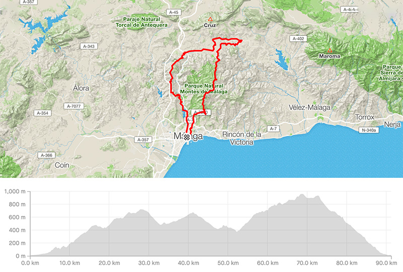
Distance: 91.29km
Elevation gain: 2008m
Elevation max: 962m
Road bike route description
It is a moderate loop behind Malaga. During any 90km you will gain elevation over 2000m.
You go out from the centre along the street Avenida Rosaleda / Santiago Ramon y Cajal. When you are close to the range of mountains follow the signs for the Botanic Garden and later follow the sign for Casabermeja.
You are on the MA-3101 for the next 25km. Climb along the lake Embalse del Agujero to the top of the narrow range of the mountain facing both valleys, N. P. Montes de Malaga on the right, Sierra del Valle del Abdalajis on the left.
When you go downhill towards Casabermeja go through and follow the A-356 (Colmenar / Riogordo / Velez-Malaga). Go along Colmenar, continue till Riogordo and turn right to the village through the A-7204. The same road will lead you back to Colmenar. Turn for the N.P. Montes de Malaga and Malaga. The A-7000 road leads you back to Malaga through a famous downhill from Puerto del Leon.