Cycling route: Marbella > Ronda > El Burgo > Alozaina > Monda > Marbella
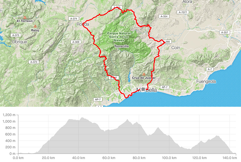
Distance: 144.17km
Elevation gain: 2767m
Elevation max: 1121m
Road bike route description
It is a nice and strong loop for those staying close to Marbella, nice km and significant elevation. Basically this is a loop around Sierra de las Nieves mountain range.
From Marbella, start riding towards west on the N-340 until you get to the highway, at that moment ride closer to the beach and over back roads in Puerto Banus. Then in San Pedro take the road to Ronda, the A-397. It is a nice climb over 20km with the 1st pass Puerto del Madronal ahead. From this pass over the undulated section comes the descent towards Ronda.
After having a break, take direction to the pass called Puerto del Viento, the highest point of the day. It is 8km from Ronda. Take the road A-366 to get there. After that the long descent to El Burgo village comes. You will be riding among pines and rocks. It is a really nice section. From El Burgo and on the same road starts another climb to the pass Puerto de Abejas. Even though it is shorter, some effort will be needed. On the top, you will find the village Yunquera and, then ride again down to Alozaina.
At the beginning of Alozaina, turn right still over the road A-366. There is a turn for Guaro + Monda, the road A-7100 som e 6km before Coin. It is a nice scenery on the quiet back road before you reach the last pass.
Leaving Monda, there is the last pass left, Puerto de Ojen, a nice wide road with the superb surrounding forest. Getting closer to Marbella, the traffic is rising and the last section of downhill is busy.